This is a series of R markdown documents that processes crash data from the University of Wisconsin's TOPS lab crash data to generate data summaries, maps of school zones, and a dynamic map for exploring the data.
| api_keys | ||
| basemaps | ||
| data | ||
| data_summaries | ||
| docker | ||
| examples | ||
| figures | ||
| html | ||
| icons | ||
| parameters | ||
| R | ||
| .gitignore | ||
| Makefile | ||
| README.md | ||
| wisconsin_crashes.Rproj | ||
This is a series of RMarkdown files that generates maps of crashes between motor vehicles and bikers and pedestrians in Wisconsin.
Data sources
- The crash data is from the UW TOPS lab: https://topslab.wisc.edu/
- School location data is from the Wisconsin DPI: https://data-wi-dpi.opendata.arcgis.com/
- County data is from the US census
- Basemaps are from StadiaMaps: https://stadiamaps.com/
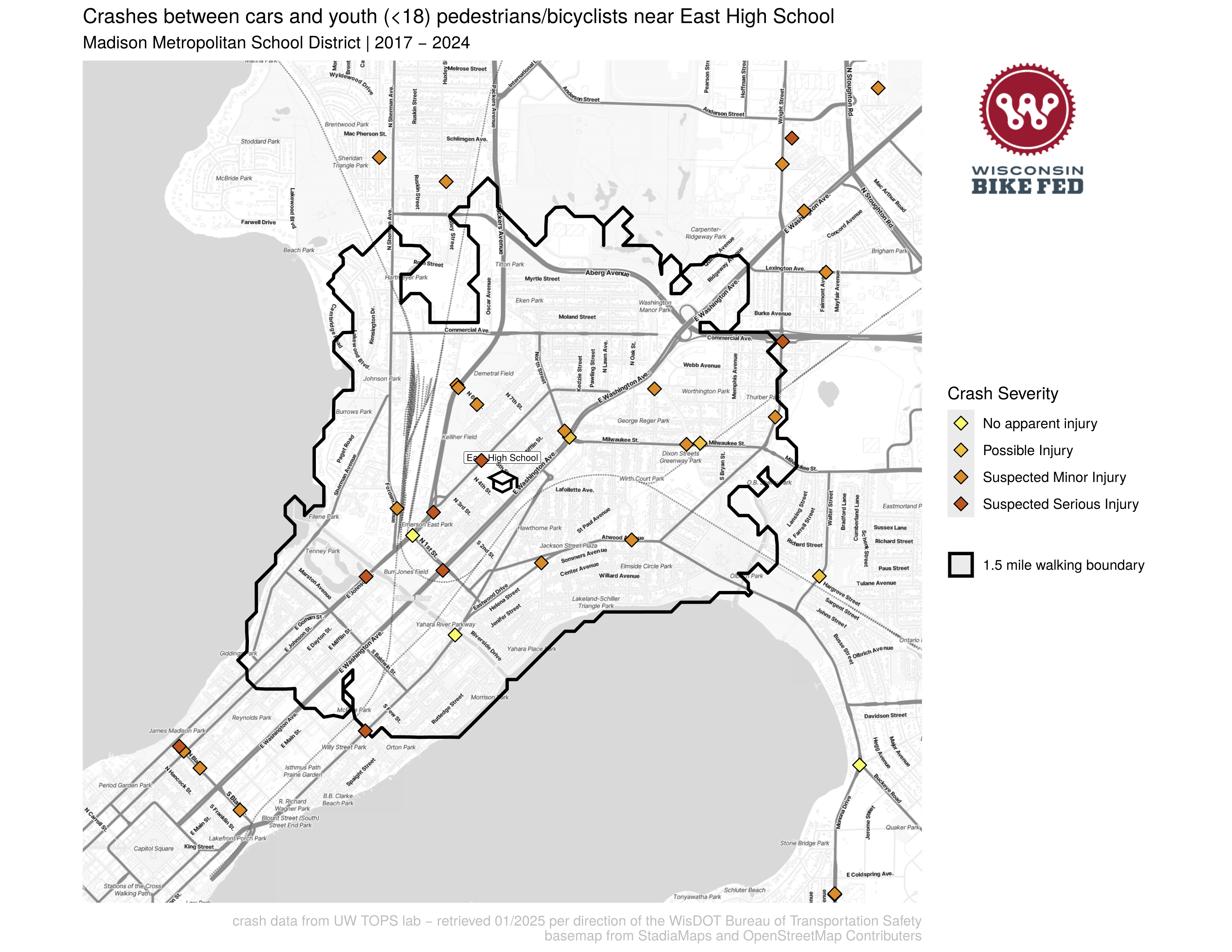
Example figures
A map of crashes near East High School in Madison, WI:
To process data and generate figures
- Pre Process TOPS data
make TOPS_data_process: This combines TOPS data exports from different years and reformats the data. - OpenStreetMap Routing Machine
make osrm: this downloads the most recent OpenStreetMap data for Wisconsin, and starts docker containers to run the OpenStreetMap Routing Machine to calculate IsoDistances. - School Crash Maps
make schoolpdfs: generates maps of all the schools in Wisconsin and where cars are hitting kids This script pulls in the TOPS data from a folder of csv’s that you’ve downloaded from the data retrieval tool. It also draws the walk boundary around each school, this is done with a OpenStreetMap routing engine that is running in a docker container. It also needs access to an API key for StadiaMaps to download all the basemap tiles. I recommend downloading the whole state and filtering the data with the script. You can edit fileparameters/run_parametersto choose what county, school type, and district to generate maps for - Dynamic Map
make crashmaps_dynamic: This takes the TOPS data and generates dynamic leaflet maps to host on our website. It generates 4 maps: without a title (for in a frame), and with a title, in both English and Spanish. - Milwaukee Specific map
crashmaps_dynamic_milwaukee: generate a web map for Milwaukee that includes more fine-grained visualizations of crash densities.
R Scripts
I'm working to move these to RMarkdown files
- City maps - generates maps for cities in Wisconsin where pedestrian fatalities occur This script pulls in the TOPS data from a folder of csv’s that you’ve downloaded from the data retrieval tool. It also needs access to an API key for StadiaMaps to download all the basemap tiles. You can specify the cities by changing the focus parameters at line ~80
- Crash summaries - generates summary csv files that summarize the crash data for a given municipality and county by age, sex, race.