This is a series of R markdown documents that processes crash data from the University of Wisconsin's TOPS lab crash data to generate data summaries, maps of school zones, and a dynamic map for exploring the data.
| api_keys | ||
| basemaps | ||
| data | ||
| data_summaries | ||
| docker | ||
| examples | ||
| figures | ||
| html | ||
| icons | ||
| parameters | ||
| R | ||
| .gitignore | ||
| Makefile | ||
| README.md | ||
| wisconsin_crashes.Rproj | ||
This is a series of RMarkdown files that generates maps of crashes between motor vehicles and bikers and pedestrians in Wisconsin.
Data sources
- The crash data is from the UW TOPS lab: https://topslab.wisc.edu/
- School location data is from the Wisconsin DPI: https://data-wi-dpi.opendata.arcgis.com/
- County data is from the US census
- Basemaps are from StadiaMaps: https://stadiamaps.com/
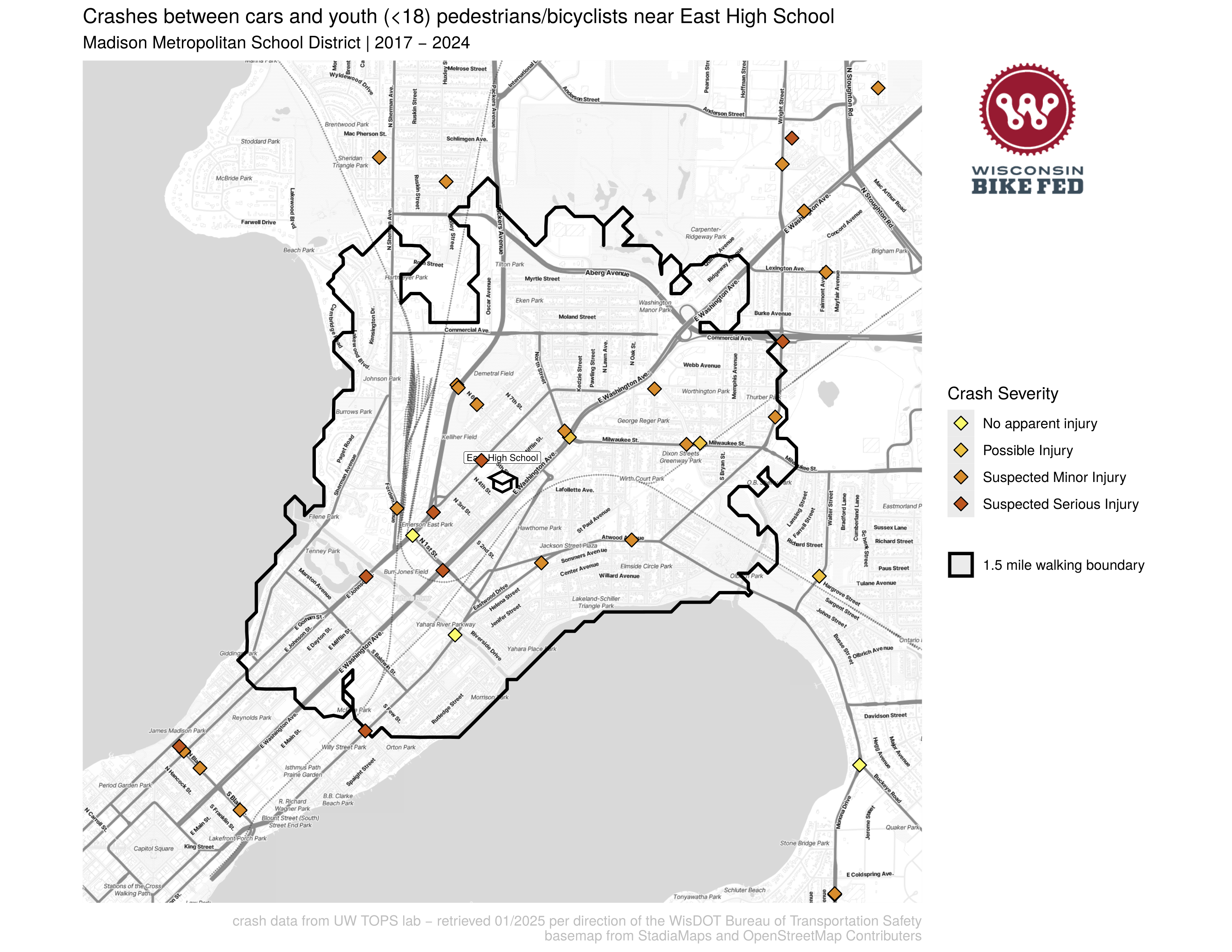
Example figures
A map of crashes near East High School in Madison, WI:
To process data and generate figures
- Pre Process TOPS data
make TOPS_data_process: This combines TOPS data exports from different years and reformats the data. - OpenStreetMap Routing Machine
make osrm: this downloads the most recent OpenStreetMap data for Wisconsin, and starts docker containers to run the OpenStreetMap Routing Machine to calculate IsoDistances. - School Crash Maps
make schoolpdfs: generates maps of all the schools in Wisconsin and where cars are hitting kids This script pulls in the TOPS data from a folder of csv’s that you’ve downloaded from the data retrieval tool. It also draws the walk boundary around each school, this is done with a OpenStreetMap routing engine that is running in a docker container. It also needs access to an API key for StadiaMaps to download all the basemap tiles. I recommend downloading the whole state and filtering the data with the script. You can edit fileparameters/run_parametersto choose what county, school type, and district to generate maps for - Dynamic Map
make crashmaps_dynamic: This takes the TOPS data and generates dynamic leaflet maps to host on our website. It generates 4 maps: without a title (for in a frame), and with a title, in both English and Spanish. - Milwaukee Specific map
crashmaps_dynamic_milwaukee: generate a web map for Milwaukee that includes more fine-grained visualizations of crash densities. - Crash summaries
make crash_data_summaries: generates summary csv files that summarize the crash data for a given municipality and county by age, sex, race.
R Scripts
I'm working to move these to RMarkdown files
- City maps - generates maps for cities in Wisconsin where pedestrian fatalities occur.